
Whitecross Street Prison
My attention was recently drawn to the plaque in the accompanying photograph. Cunningly designed in the style of official commemorative blue plaques, I noted the building so commemorated before realizing the plaque was not official and that the building referred to would (to my mind) have been in an odd place between the dates referred to. Enquiries suggested this was one of four plaques erected in June 2010 in connection with a street party in Whitecross Street (an interesting and historic old street with a strong sense of local community and still boasting an active street market). You can look up Hedonist London for yourself if you like!

Having been alerted to the existence of Whitecross Street prison, I quickly discovered it was actually located near the south end of that road, unsurprisingly within the City of London walls, in the area known as Cripplegate. That area was flattened during WW2 and the corresponding section of Whitecross Street expunged, a short section surviving as part of Silk Street. I can best indicate the site of the prison as the place which is today the Barbican Centre.

Whitecross Street Prison may be found on this map of London in the centre. St Giles Church is perhaps the most recognizable of the very few buildings from this time still standing (and this is reconstructed from a wartime ruin), This is from Wyld’s map of London produced during the 1790s.
My interest in the prison was much excited by its association with the Metropolitan Railway. The prison did not actually have a long life. It was designed William Montague, Clerk of the City Works. Alderman Matthew Wood laid the first stone in July 1813 and the building was completed in 1815, intended to be purely a debtors prison. It was designed to hold 500 people in six entirely independent wards, one set apart for females and another for freemen of the City. Those liable to be imprisoned included quite a large number who owed as little as a shilling who could be committed for up to twenty days. This alone was thought to account for 2000 prisoners a year. Curious to say, prisoners were fed at the cost of philanthropists who were allowed to display boards outside, an early kind of sponsorship, perhaps. The defective logic behind imprisoning decent people so they could not attend to their business, making the debt problem worse, was not addressed until 1869 when the Debtors Act put a stop to this kind of treatment for trivial sums and the prison soon closed (the remaining inmates being transferred to Holloway).

Whitecross Street Prison
The Metropolitan Railway was extended from Farringdon to Moorgate in December 1865, the line taking a slightly indirect route to skirt round the north wall of the prison. However, during 1864 it appears that the Metropolitan had second thoughts about whether their station at Moorgate would be large enough to accommodate the trains not only of its own railway but those of the Great Western, the Great Northern, the Midland, the London, Chatham and Dover and, according to The Railway News, the London & South Western Railway (presumably from the Richmond direction unless it was a mistake and London & North Western was meant). To that end, it was proposed to purchase extra land to the south of its authorized line between Aldersgate and Moorgate, including the whole of Whitecross Street prison, powers being obtained in the Metropolitan Railway Act 1865. The Railway News claimed this was because the Metropolitan wished to extend the terminal station facilities, though exactly what kind of terminal was in mind we do not know. The prison could only be purchased by consent, and then with 18 months’ notice to quit, while the existing line was in an advanced state already. In fact the station opened with seven platform roads and with no requirement to serve LSWR/LNWR trains and this appears to have been quite adequate. Notice to acquire the prison site at that time was not therefore given and the huge expense to the company that it would have entailed (which included enlarging Holloway prison as a substitute) was avoided.
The 1869 Debtors Act, already mentioned, resulted in the number of prisoners at Whitecross Street being reduced to about thirty, and in 1870 the prison closed its doors (28 prisoners, including 2 women, were taken to Holloway at the beginning of August but allowed the same privileges as they had enjoyed previously). The Home Secretary designated Holloway Prison as the future home of debtors and on 11 October 1870 ordered that Whitecross Street prison be pulled down and the materials comprised in the old prison be sold.
The Metropolitan Railway arranged to acquire the prison site, no doubt relieved that the requirement to pay for Holloway to be enlarged no longer applied. The Metropolitan therefore found itself in possession of a large area of land bound on the north by their railway, on the east and west by Whitecross and Redcross Streets and on the south by a school and some other buildings fronting Fore Street. Whether the land was bought speculatively I have not determined, but with extension to Bishopsgate and Aldgate in hand and (apparently) sufficient space available at Moorgate it is hard to see any need for the space for passenger traffic. Possible use for goods is more likely.
This rather awkward site soon attracted the attention of the Midland Railway which was keen to have a goods depot with the City and arrangements were made to lease the site from the Met, powers being authorized to provide a connecting line into the depot in the Midland Railway Act 1873. The depot opened in 1874. The cost of erecting the vast new buildings were a £120,000. The works were not completed until 1877 and opened 1st Jan 1878. The Midland had to pay the Met a minimum rental of £2500 a year from 1874. The goods station was entirely under cover and comprised a vast red brick and stone building covering an area of 2000 square yards and having a floor area of 4300 square yards. The main building was 250ft long by 50ft wide and its six floors (including basement) rose 70ft above the street. The Midland Railway’s history offers a further description, as follows:
Thirty-six iron columns, placed in two rows, support the floors, each of these columns being practically continuous from the basement to the tie-beams of the roof; all the floors are fireproof. Hoists are provided, which enable goods to be transferred to any of the floors, and railway wagons, with their load complete, can be raised from the level of the Metropolitan Railway to the first floor. Adjoining the principal warehouse is a large area of ground, covered by six bays of roofing. The roofs are of iron, supported upon columns and girders, and receive light through broad belts of glazing. This great space is for the sheltering of the carts and vans during the times of loading and unloading goods.
A technical description in 1890s explains that there were nine hydraulic platform cranes of which two could lift 50 hundredweight (cwt), five 25cwt and two 20cwt. The two wagon hoists could lift 20 tons each (more than a very well loaded wagon). There were two cage hoists that could lift 20cwt and two jigger hoists that could each raise 30cwt. Fifteen hydraulic capstans could haul a ton each. Five traversers were provided, three worked by the capstans and two by direct hydraulic power. The hydaulic power was stored in two 20ft stroke accumulators and distributed by 6-inch main. The power was created by a pair of steam driven hydraulic pumps and the steam pressure of 100lbs per square inch was created by three boilers. Later descriptions indicate that some of the capstans were installed or converted to electric operation.
A connection with the Metropolitan was made just east of Aldersgate Street station and sorting sidings were installed at basement level with goods shifted mechanically to higher levels. Road access allowed goods to be delivered or collected by road and there was considerable storage space.

This shows the basement plan of Whitecross Street depot, Metropolitan line at bottom. Wagons were moved around by capstans, traversers and turntables. A pair of wagon lifts connected with ground floor level. North is towards bottom on this diagram, Whitecross Street to left and Redcross Street to right.

From a map of 1895 the arrangement of the interior of the depot mat be seen at street level. Bear in mind this has north at the top when comparing with basement level plan above where north is at bottom. Wagons were brought to and from street level by hoists and moved by capstans and traversers to a convenient point to exchange goods with road vehicles. There appear to be three road entrances from Redcross Street on left. he main warehousing is on right with separate entrance from Whitecross Street.
Within the depot trains were brought into one of the two reception roads and wagons were detached from the middle and moved around individually using turntables and electric or hydraulic capstans and ropes. Lifts were used to take wagons to the upper level for goods trans-shipment. The area on the Whitecross Street side looks as though it was used for warehousing traffic with a separate loading area.

Whitecross Street depot (Redcross Street entrance at west end of depot) in 1929.
Although traffic through the depot dropped over the years, during the early 1930s it was still dealing with about 6000 tons a week. However, there were moves to concentrate the transfer of goods between road and rail to a smaller number of large depots and Whitecross Street lost its direct rail connection from 1st March 1936. It remained open for storage and the collection and delivery of goods and parcels by road vehicle. It was soon being described as a parcels depot. Unfortunately part of the depot was destroyed by bombing on the night of 29th December 1940 during the blitz. The depot was hit and seriously damaged, in the stables 99 stalls were destroyed by fire but fortunately loyal staff managed to extract the horses safely. It looks as though part of the premises was repaired as a 1953 telephone directory still lists the building as a parcels depot, though maps suggest the entrance in use was the one at the other end of the building in Redcross Street. However the naughty Great Northern Railway had many years previously also opened a goods and parcels depot on the East side of Whitecross street (opposite the Midland depot) and by 1938 is found sharing the old GNR building with the LNER instead of maintaining its own office accommodation. This might sound odd as the mantra is that these railways were in competition. They were not. All parcels, much freight and all the Anglo Scottish passenger traffic was pooled and both companies cooperated in order to save costs. Clearly the LMS depot was maintained in the other side of the road until the war ot we would not know about a damage report, but which of these two premises is being referred to in 1953 I cannot at the moment say.

Whitecross Street entrance to the goods depot (looking south, depot on right), after the 1940 bombing raid. Although badly damaged much of the structure remained standing and was not in fact demolished until Barbican site clearance began in 1960.

This wartime view, looking east, is taken from the Jacob’s Well Passage (footpath) bridge towards the tunnels lying either side of Redcross Street shortly after heavy bombing. This is the site of the junction connecting the Widened Lines (centre tracks with trucks of rubble) and the Whitecross Street goods branch, which passed through arch on the right. Track is still visible along the branch although trains had already ceased to served the depot.

The City of London Collage collection includes a 1942 picture looking towards the west, showing the goods depot building, surviving amongst the devastation. It is the large building, upper centre, with Whitecross Street in front. Just visible is the Metropolitan Line snaking round its right hand side (bridges can just be made out). Nearest left-right road is Moor Lane, and the Metropolitan Railway (Moorgate) substation is visible beyond, next to railway. St Giles Cripplegate church visible at top left. [Collage Collage Record No 36618, Catalogue No M0020324CL]
The old Whitecross Street land remained at least partly derelict until absorbed by the Barbican development in the 1950s/60s. During this work the kink in the route between Moorgate and Aldersgate was removed when the Circle Line and Widened Lines were rerouted a little to the south, passing right through the centre of what had been the goods depot (and under the Barbican Centre).

This 1946 view looking south-east shows Moorgate station towards top left with Aldersgate (now Barbican) just out of shot bottom right. The connecting Metropolitan Line is visible. The wartime devastation is very obvious. In the centre, just above the railway, may be seen Whitecross Street goods depot, damaged during 1940 bombing (roof damage can just be made out and looks as though there was not much attempt at repair). Whitecross Street is the road at east (left) side of depot and Redcross Street runs along west (right hand) side.

This view looks west from Moorgate station and as diesel locomotives are in operation but there is no sign of ‘A’ stock, I estimate the image to be 1961. Little work has yet taken place on the Barbican development and, although the building behind the Whitecross Street frontage may partly have gone, the characteristic sheds at the rear (top left corner) appear intact and may well still be in use.

This view from a crane west of Moorgate station early 1964 shows work having just started laying out the new route to the left of the existing one, looking towards Aldersgate. Near the top left may be seen a lone surviving stone arch next to what had been Whitecross Street. I think this is the base of the tower at the southern end of the former goods depot, the rest having disappeared to make way for the excavation for the new line.
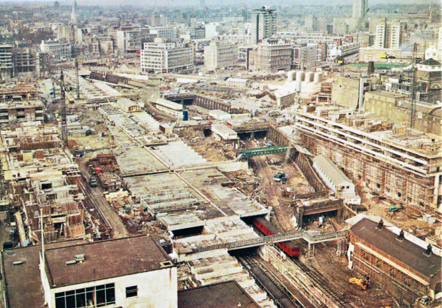
This 1965 view from a tower Crane next to Moorgate station looks west from smae position as previous photo but in following year later. The old Metropolitan route to Aldersgate (now Barbican) is visible to the right of the train with the former bridges at Milton Street, Whitecross Street and Redcross Street, in sequence from camera. The new route lies in the concrete box from which train is emerging. The box passes through the centre of the old goods depot site, to the left of the old Whitecross and Redcross Street bridges.

This 1964 view looks east from the Aldersgate (now Barbican) station end with Circle Line on left and Widened Lines on right.. In foreground is remnant of Jacobs Well Passage and beyond this is the partially demolished Redcross Street bridge. There had been a third arch under Redcross Street, to right of these tracks, which was the rail access tunnel to the goods depot beyond the bridge (see earlier image); the actual junction was in the foreground at Jacobs Well bridge. Work has just begun setting out the diversionary route which passes through the old goods yard site.
You will appreciate that the old prison was about 400 yards from the rogue plaque and it made me wonder why the mighty City of London has not itself erected a plaque to the prison on its Silk Street flank wall. However, I believe there had been a plaque to the prison on the wall of the goods depot. It would be good if any photographs of this have survived.

Whitecross Street Goods Depot site today. This image was taken looking south along what had been Whitecross Street. The original path of the Metropolitan and Circle line passes left to right roughly where the main entrance is seen. The goods depot was immediately beyond, if you can imagine the road continuing south rather than turning away. The location is therefore slightly to the north of the wartime image above, but as close as I could get.
Middlesex House of Correction
The Metropolitan Railway had already had a brush with the prison business when its original line was being designed. The route devised in 1853 was a little to the west of its eventual alignment and was to run in a long tunnel beneath the high ground south of Kings Cross, which took the route directly beneath the Cold Bath Fields prison (then called the Middlesex House of Correction) and Cold Bath Square. Since the line was in tunnel it is not apparent why it was felt essential to use this route and no other, but this was likely to prove very expensive. The Act noted that under general legislation the railway would have to purchase the whole of the lands of the Cold Bath House of Correction and detailed conditions were laid down about how this was to be done. Amongst other things, the Metropolitan was to obtain and deliver to the Middlesex quarter sessions fifty acres of freehold land within Middlesex, located between six and nine miles from the general post office, which was suitable for a prison and which was within half a mile by road of a railway station. The site having been approved, the railway would then have to build at its own expense a new prison upon it, suitable for 1500 inmates as well as the necessary staff, and including all fittings and a secure boundary wall. The Act then set out what was required, including that every prisoner would have their own cell and all details were subject to approval of the prison authorities. With the best will in the world, this was going to be extremely expensive.

Aerial interpretation of the Cold Bath Fields prison site. This is shown not for the detail (which can easily be looked up) but to show the scale of what the Metropolitan Railway would have had to replace.
What was more, the railway could not enter upon any of the lands of the existing prison until the new one was built. Nor could they exercise its borrowing powers, except for constructing the prison and buying the land for its construction, until the prison was finished. The Act also required the company to build a station in the vicinity of the old prison and provide free travel over their entire system for prisoners and their keepers going to or from the new prison for whatever purpose, if necessary in reserved carriages. This sound particularly onerous in view of what we know about the railway’s later development, but at the time in discussion (1853-4) the Metropolitan was only planned to go between the City and Paddington and any prison would probably have had to have been some distance from it and huge abstraction of traffic was correspondingly unlikely.
Why the Metropolitan acceded to all this in the Act I have not gone into, but when the significance of the obligations had sunk in, moves were made to get rid of these onerous and expensive requirements. Discussions at first centred on whether the prison authorities would simply allow the Met to obtain a wayleave to tunnel under the prison but the authorities were unshakeable that this was not going to happen. I suppose one can understand why the authorities were actually quite reluctant to allow large scale tunnelling beneath a live prison; there might have been some interesting branch tunnels.

This is from the deposited plans and shows the prison area and the centre line of the Metropolitan running directly underneath the cell block. Kings Cross to left, Farringdon to right.
In due course, the railway concluded that it really did not want to engage in prison building and that the only solution was to alter the route. A further Act of 1855 authorized the route to be diverted to the north, running under Bagnigge Wells (now Farringdon) Road, just outside the gates of the prison, and avoiding the need for its purchase (and thereby avoiding the need to enter the prison-building business).
I can add that the prison opened for business in 1794 and took its name after the cold bath spring, a medicinal (chalybeate) spring discovered in 1697 and available for a while from a small building in Cold Bath Square. After early abuses, the prison eventually adopted the silent association system where talking was forbidden between prisoners. There were some less pleasant innovations, such as the treadmill. Being found increasingly out of date after the government took over prisons, it closed in 1885 and the land was transferred to the Post Office in 1889 and gradually rebuilt (the last of the old sections was rebuilt only in 1929). After a variety of postal uses it became the Mount Pleasant sorting office, about as inappropriate name as one could find for the present dreary buildings (and adjacent bombsite). In fairness post-privatization Royal Mail has seriously attempted to make these unpromising buildings more attractive and I think I must concede a measure of success.

View of Mount Pleasant post office building from south east corner, Farringdon Road on right. The building follows the site boundary of the former prison. It had been intended the Metropolitan would have passed under this site in tunnel about half way along the frontage visible here.
