There is a place on the Somerset coast, called Burnham on Sea, not very far away from Weston super Mare. It is an unassuming seaside town quietly getting on with itself and in better shape than many. It has a picturesque parish church with a tower that leans appreciably, but not, apparently dangerously. By quirk of fate it isn’t on the railway any more, but it was not only once on the railway, but also once served railway shipping services, hence my interest in the place.
 |
| Burnham Pier from Esplanade |
There is at Burnham what might be termed a pier, but is better described as a slipway (which is what it is used for today). The slipway hold two interests for me. First, it has a curious relationship with the Ordnance Survey, which, apparently on some random basis over seventy years or more shows it or omits it from its maps. Secondly, it was built by the Somerset Central Railway in 1862 and its survival is something of a curiosity. I shall call it Burnham Pier, as that is shorter, but do not imagine it looks anything like Brighton or Bournemouth.
 |
| Map showing pier. Curved road leading towards pier is old railway. Note low and high water marks. |
The Somerset Central Railway opened from Highbridge to Glastonbury on 28 August 1854 and was later much extended to Wells and a junction with the Dorset Central at Evercreech. It then became part of the Somerset & Dorset Railway. Highbridge was an inland port near the coast, on the River Brue, and could offer convenient wharfage facilities for the railway to exchange goods. By the time the railway opened it was eyeing up the possibilities of trade with some of the new or enlarged ports on the Welsh coast, South Wales being an extremely inconvenient journey from Somerset (or points west or south) by road. For passenger traffic, Highbridge was not then very suitable and a 1½-mile extension, north west, to Burnham was considered, with some facility there for connecting passenger trains with steamers. This opened on 3 May 1858 and, like the rest of the Somerset Central, was operated by the Bristol & Exeter Railway. It was also a broad gauge line, and required converting to standard in the 1870s
The station was built about 50 yards east of the sea wall, at the south end of Alfred Street (now High Street), and comprised one of those early affairs where a wooden shed covered one end of the main platform (there was a runround line outside the shed, too, soon acquiring its own platform for excursion trains). Beyond the station, the track continued until it ran onto a newly-constructed stone pier, the railway continuing to the end. Reports suggest the pier was 900ft long. Today it only extends 740ft so the quoted length may include the short section into the station (I believe it has been cut back slightly though). There was a substantial level difference between the pier and sea wall, resulting in a formidable incline (then of of 1:23, but today steeper); this precluded operation of locomotives or passenger stock entering the pier, where the track seems to have been used for trucks delivering goods, produce and cattle to the steamers, and possibly passenger luggage. The final part of the trip to the slipway was initially by propelling locomotive and then control by wire rope. There is an unsubstantiated story of a loco running away onto the pier, only the drag of the high tide water preventing in going off the end.
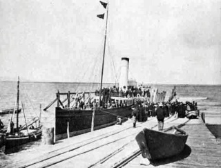 |
| Burnham Pier in 1908, short siding on right. |
On the opening day the Iron Duke berthed alongside the pier on a trip from Cardiff, arriving at about 10 am. Later the same day an excursion train from Bristol arrived, carrying about 700 people and a railway brass band that made its way to the pier (and possibly enjoyed a short voyage). The following month (June) the Cardiff Steam Navigation Company began running the steamer Taliesin on a regular basis. It was certainly in use during May 1858 for a paddle-steamer service to Cardiff, a service that endured, on and off, for some years. It is impossible, today, to imagine boats coming anywhere near the pier, let alone calling at it, but channels were created to allow large boats to come alongside, at least at certain states of the tide (which has a curiously large rise and fall here); the tidal position here was to become a real problem. There was an occasion when the SS Ruby got stranded at Burnham during a receding tide and broke her back. To reduce constant (and partly ineffective) dredging, a ‘sluicing pond’ was constructed to reduce the effect of silting.
 |
| In this 1915 postcard the track can be clearly seen on the right, the rails situated in gulleys in the setts. The remains of the various wooden mooring or guiding structures can be seen on left. |
The Somerset & Dorset was part owned by the Midland Railway and as the difficulties of improving small southern ports mainfested themselves the company gradually shifted its shipping interests to larger ports further north. In 1905 parliamentary powers were sought to sell or abandon the pier, which in due course resulted in its purchase by the Burnham Pier company. Steamers continued to operate, one service served Barry Island, on the Barry Railway. This railway obtained powers to develop the pier, but it was not a successful venture, and in 1910 its four vessels were sold. Steamers were also operated by P&A Campbell Ltd, but these had ceased by 1900.
 |
| The end of the pier at low tide before resurfacing.It was in this state possible to make out where the old track had been. The remains of extensive wooden posts can be seen on right. Huge arrays of posts at one time adorned both sides of pier to assist ships manoeuvring. Attrib: Chris Talbot , Geograph.co.uk. Creative Commons Licence. |
After use by steamers, the rails next to the railway station were connected into the lifeboat house, and the pier was then used to launch lifeboats from; the lifeboat station and siding went out of use in 1930, after which the pier was disconnected from the station (the surviving stub end to what was now the esplanade being used as an engine run round). The esplanade was extended south across the former line at about the same time, but there was never (I think) any level crossing. The pier rails remained in position for some years, but most gradually disappeared, though it is recorded a few were still in situ after WW2, and my own inspection about a decade ago still found a couple of short sections in the stone setts (that marked the edges where other rails had been).
 |
| Sea end of pier in 1970 (and as I first recall it). I’m wondering if assymetric position of track (of which a small section of rail then survived) was because it was originally broad gauge. If so the wide rail hasn’t left an obvious trace. [The late Chris Handley] |
The Barry Railway, having abandoned the pier in 1910 and its aspirations to develop the pier and its traffic, appears to have left it to the local residents to sort out and it soon became the responsibility of the local authority, in whose hands it remains. It was handy for a while for local fishermen to use to land small catches for sale in the town. It was last used by a large ship in 1929, the dredger Manley, used to convert part of the sluicing pond into something more useful. After its departure the channels were simply allowed to silt up..
 |
| Burnham station showing truncated pier line now used as run round. |
 |
| Similar view today (taken a little farther back). Station building had been dead ahead. Pier behind photographer and link line was to right of bollard. |
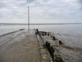
For some reason the far north end (where it joins the esplanade) has been replaced by a short concrete section, probably because the original metalwork had corroded, but when I found the pier it was largely surfaced with setts, and seemed to me perfectly satisfactory. A recent visit shows that the Council (which now owns the pier) has attempted to resurface it. This did not at first work as the tide lifted the surfacing (the setts were fine). This seems to have been fixed now. To me it is a great shame the historic pier end has been obliterated by ubiquitous tarmac that gives the impression it is a main road (an appearance supported by the yellow lines). No-one cares about history today, it seems, or no-one official anyway.
 |
| Even at moderately low tide the pier end is covered for some distance. This cannot have made it very useful (assuming tide levels haven’t altered much over last century). |
The station at Burnham closed to passenger traffic on 29 October 1951, but remained available for seaside excursion trains until 8 September 1962. It finally closed to goods on 20 May 1963. It is perhaps surprising train services to a seaside resort were withdrawn quite so early, but perhaps a revealing indication that much of the business came from excursion trains. Having said that, the 1950 timetable reveals the Burnham line was worked as a branch from Evercreech, with just four trains a day and exceedingly poor connections, so perhaps that might have had something to do with it. The trackbed lay derelict for many years but in the 1980s a road (Marine Drive) was built along much of it and the site of the station is not obvious unless one is in the know.
 |
| Burnham on Sea station looking towards pier, probably after closure to regular passenger trains. The excursion platform is on left. |
During the period the pier was in active use, the Somerset & Dorset at various times itself owned eight ships of various kinds, the smallest of 59 tones and the largest 239 tons (a wooden paddle steamer). The last two ships were disposed of in 1934, the Radstock being sold and the Julia scrapped. Many other ships were charted by the railway as needed, however. It is curious to see the S&D owning ships when it never had any rolling stock of its own.
The main service operated in the early years was a ferry between Burnham and Cardiff. The S&D originally had no powers to operate ships, which were initially hired in but soon were purchased and operated by an associated company, the Burnham Tidal Harbour Co (which never developed the intended tidal harbour but was useful in being able to run ships as though it were the railway itself). One ship was briefly sent to the south coast to operate a Poole – Cherbourg service, a connecting Poole – Burnham train allowing through traffic from Cardiff using the Burnham ferry. This was a roundabout route, but not as roundabout as a ship having to run round the Scillies. The railway last ran the Cardiff service in 1888 after which the pier was of little interest to the railway and it fell increasingly into disuse for its original purpose.
Below are some map extracts showing the area. The ‘Explorer’ 2½-inch sheet, edition A of 1999 also fails to show the pier, though it was on previous and later editions. How things like this happen I could not say. Unfortunately I do not have this sheet and would welcome an extract of the relevant part.

 |
| A selection of maps of the area. Top row are 1-inch maps. Top left – 3rd edition 1905 (railways to 1911. Top middle – Popular 1918, revised 1913 but based on survey 1882-7. Top right – New Popular 1946, revised 1930. Bottom left – 7th Series 1958, roads to 1961 (pier missing), Bottom Middle – 7th Series B 1971. Bottom Right – 1:50,000 1974. |
About machorne
I have always lived in London and taken a great interest in its history and ongoing development. This extended into the history of its transport services, about which I have written a number of books - I have spent most of my working life working in the industry and observing changes from within, mostly to the good, but not always so. I continue to write, and have a website with half finished stuff in it so that it is at least available, if not complete. Several new books are in hand. I have many 'works in progress' and some of these can be found on my website; the we address is http://www.metadyne.co.uk


What an interesting piece about the railway pier or jetty in Burnham on Sea. I have lived in the town for most of my life and am always interested in reading about the historic aspects. Your opening line at it being an un-assuming seaside town just getting along with things was very fitting!
I edit a community monthly magazine that is delivered free once a month and wondered if you would be interested in putting a piece in about the pier? It could run over a couple of editions as words tend to be limited to 320 for the free editorial. Let me know if interested. Jacqui. Jacqui.strong@hotmail.co.uk
LikeLike